VANCOUVER, BRITISH COLUMBIA, September 17, 2018 – West Kirkland Mining Inc. (WKM:TSXV) (“West Kirkland”, “WKM” or the “Company”) reports that recent results from underground channel sampling in historic gold mining adits, shallow air-track drilling and compilation in 3D of historic drilling with WKM mapping has highlighted potential for additional gold resources on the district-scale land position controlled by the Company near Tonopah, Nevada. WKM controls 75% interest and operates the Hasbrouck gold project with 762,000 ounces of proven and probable reserves (45,270,000 tons at 0.6 Au g/t; 8.0 Ag g/t for 10,569,000 contained Ag ounces) and has a 100% option interest in the Gold Mountain area which is the subject of recent exploration.
WKM sees good potential for further drilling to outline an area for open pit potential, rather than the previous historic underground mining method, as well as along strike from the occurrence being tested. The objective of a further drill program would be to add reserves that could be trucked to the planned Three Hills pit and permitted heap-leach pad area. The new gold zone is on historic patents partly in an area already disturbed by mining, simplifying permitting work required for mining and trucking.
R. Michael Jones said, “We are very excited about the potential to add to early ounces from at-surface mineralization located near the Hasbrouck Project. The strong project economics, (NPV5 Post Tax estimated at US$120M, IRR 43% (US$1,275/oz Au) (Technical Report and Updated Preliminary Feasibility Study for The Hasbrouck and Three Hills Gold-Silver Project, Esmeralda County, Nevada, USA, Report Date: September 14, 2016) could be positively impacted by any incremental ounces added to the same project capital footprint.”
NEW ASSAY RESULTS FROM UNDERGROUND CHANNEL SAMPLING
Underground channel sampling on historic gold veins from the early 1900’s completed by the company, after safely entering underground workings, has outlined grades of interest for modern heap leach extraction and open pit mining. The underground sampling provides sections approximately 90 feet (30 meters) vertically below surface on three levels across the mined veins and surrounding rock. The underground workings are flat adit tunnel drives that go into the hillside. The adit workings go along gold mineralized veins and cross-cut them. Although the workings drove along veins for up to 1,800 feet (550 meters) they were exploratory in nature and extracted only a small portion of the mineralized structures. Historic literature references these workings as continuing 900 feet (274 meters) at levels below ground level but these deeper levels were not accessed by WKM.
The underground workings and mineralization correlates well with surface channels and drilling by WKM. The shallow low-cost drilling by WKM did not cross-cut the whole zone as outlined below. Historic drilling that undercut the workings more fully provides good grade and position correlation.
| 2018 Underground Composite 20' Rock Chips – Adit Area |
|
| Adit Level |
Length (ft) |
Length (m) |
Au Grade (g/t) |
Orientation |
| 6347 Level |
140 |
42.7 |
0.69 |
Across strike |
| 6300 Level |
160 |
48.8 |
0.86 |
Across strike |
| 6300 Level |
120 |
36.6 |
0.25 |
Across strike |
| 6260 Level |
120 |
36.6 |
0.14 |
Across strike |
| 6260 Level |
80 |
24.4 |
0.64 |
Across strike |
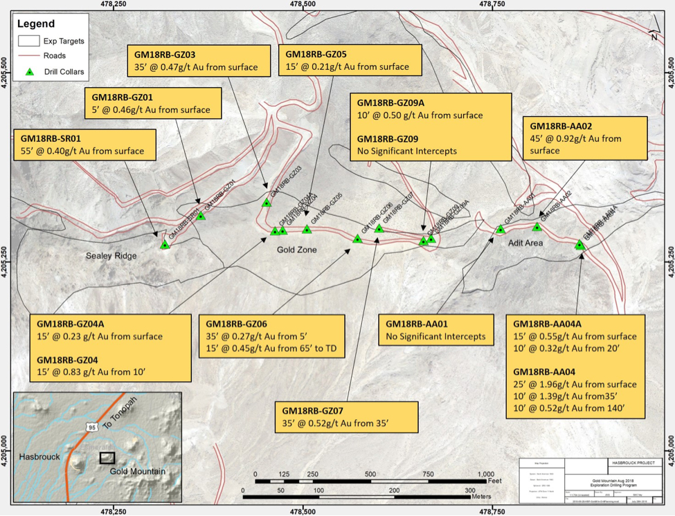
2018 DRILL PROGRAM IN THE ADIT AREA
WKM completed four air-track (rotary air-blast hole type drill) holes in the Adit Area. This drilling method is in-expensive and has limited depth penetration capabilities but the objective of getting some sense of vertical values where surface channel samples returned gold values was achieved. The holes provide results with grades similar to the company reserves in the region and demonstrated potential consistent with the underground and surface sampling.
One hole had results that indicated it was beyond the Adit Area gold-bearing structures.
Follow-up with a larger reverse-circulation drill and 3 or 4 holes will be required to fully assess the grade and width profile in the Adit Area. Detailed mapping and surface gold values provide a clear target area.
| 2018 INTERCEPTS – ADIT AREA |
| Drillhole |
Interval (ft) |
Interval (m) |
Au Grade (g/t) |
From (ft) |
From (m) |
Comments |
TD (ft) |
TD (m) |
| GM18RB-AA02 |
60 |
18.3 |
0.77 |
Surface |
Surface |
Full width of veins not tested |
75 |
22.9 |
| GM18RB-AA04 |
150 |
45.7 |
0.49 |
Surface |
Surface |
Bottomed in mineralisation |
150 |
45.7 |
| GM18RB-AA04A |
30 |
9.1 |
0.40 |
Surface |
Surface |
Full width of veins not tested |
35 |
10.7 |
* GM18RB-AA01 drilled to 95' (29m) but encountered no significant

HISTORIC DRILLING IN THE ADIT AREA
Drilling by Falcon in the 1980s and Echo Bay in the 1990s provided results consistent with the results from underground sampling by WKM both in grade and position of the mineralized structures.
The overall target area into the hill-side of the Gold Mountain Adit area to the west and towards the Divide Lode to the east provides a target area of approximately 600 feet (180 meters) along strike, 600 feet (180 meters) vertically and 150 feet wide (50 meters).
| HISTORIC DRILLING INTERCEPTS - ADIT AREA |
| Drilling |
Interval (ft) |
Interval (m) |
Au Grade (g/t) |
From (ft) |
From (m) |
Comments |
TD (ft) |
TD (m) |
Company |
| DH135/C1 |
40 |
12.2 |
1.19 |
60 |
18.3 |
Bottomed in mineralisation |
100 |
30.5 |
Falcon |
| CTC2 |
10 |
3.0 |
0.26 |
40 |
12.2 |
|
60 |
18.3 |
Falcon |
| C2-45 |
145 |
44.2 |
0.72 |
Surface |
Surface |
|
150 |
45.7 |
Falcon |
| C2-70 |
150 |
45.7 |
0.22 |
Surface |
Surface |
Bottomed in mineralisation |
150 |
45.7 |
Falcon |
| C3-45 |
150 |
45.7 |
0.65 |
Surface |
Surface |
Bottomed in mineralisation |
150 |
45.7 |
Falcon |
| C3-70 |
70 |
21.3 |
0.44 |
Surface |
Surface |
Bottomed in mineralisation |
150 |
45.7 |
Falcon |
| 20 |
6.1 |
0.33 |
130 |
39.6 |
| C4 |
40 |
12.2 |
0.21 |
90 |
27.4 |
|
150 |
45.7 |
Falcon |
| C5-45 |
65 |
19.8 |
0.30 |
Surface |
Surface |
|
150 |
45.7 |
Falcon |
| C6-70 |
90 |
27.4 |
0.24 |
Surface |
Surface |
|
90 |
27.4 |
Falcon |
| G-3-1 |
15 |
4.6 |
0.29 |
45 |
13.7 |
Bottomed in mineralisation |
60 |
18.3 |
Falcon |
| G-3-2 |
15 |
4.6 |
0.27 |
Surface |
Surface |
Bottomed in mineralisation |
15 |
4.6 |
Falcon |
| G-4-2 |
45 |
13.7 |
0.35 |
Surface |
Surface |
Bottomed in mineralisation |
45 |
13.7 |
Falcon |
| G-5-2 |
15 |
4.6 |
0.64 |
Surface |
Surface |
|
40 |
12.2 |
Falcon |
| G-5-2A |
15 |
4.6 |
0.39 |
Surface |
Surface |
|
40 |
12.2 |
Falcon |
| GM-01-90 |
135 |
41.1 |
0.43 |
Surface |
Surface |
|
345 |
105.2 |
Echo Bay |
| GM-05-90 |
160 |
48.8 |
1.04 |
450 |
137.2 |
|
635 |
193.5 |
Echo Bay |
| GM-07-90 |
170 |
51.8 |
0.58 |
Surface |
Surface |
|
445 |
135.6 |
Echo Bay |
SURFACE CHANNEL SAMPLES IN THE ADIT AREA ( PREVIOUSLY REPORTED)
Surface sampling in the Adit area is consistent with the structures and width in underground sampling and drilling. There may be some surface enrichment of grades.
| SURFACE ROCKCHIP INTERCEPTS - ADIT AREA |
| Traverse |
Interval (ft) |
Interval (m) |
Au Grade (g/t) |
Description |
| SP-01 |
140 |
42.7 |
4.32 |
Across strike |
| Roadcut 4 |
220 |
67.1 |
0.88 |
Along strike of Adit Area Prospect structures |
| NP-01 |
140 |
42.7 |
2.14 |
Along strike of fracture zone into drillhole GM-09-90 |
| AA-01 |
120 |
36.6 |
0.75 |
Across strike. Falcon Pit Bench IV |
| AA-04 |
60 |
18.3 |
1.23 |
Across strike |
| AA-05 |
60 |
18.3 |
1.98 |
Across strike |
STRIKE EXTENSION DRILLING AT GOLD MOUNTAIN
Surface sampling has outlined a clear exploration target along strike from the Adit Area. Unfortunately, the low-cost air-track drill could not drill deep enough to effectively test this area, resulting in a number of holes ending in gold mineralization. Initial drill results provide targets for more drilling and indicate that surface sampling may provide grades higher than below the current surface. More drilling is required. The Gold Mountain area is close enough to the Company reserves that similar grades to the reserves would be of interest for processing on the permitted heap leach pads in the Company’s current mine plans and capital foot print.
| 2018 INTERCEPTS - GOLD ZONE |
| Drillhole |
Interval (ft) |
Interval (m) |
Au Grade (g/t) |
From (ft) |
From (m) |
Comments |
TD (ft) |
TD (m) |
| GM18RB-GZ03 |
35 |
10.7 |
0.47 |
Surface |
Surface |
|
80 |
24.4 |
| GM18RB-GZ04 |
15 |
4.6 |
0.83 |
10' |
3 |
Bottomed in mineralisation |
25 |
7.6 |
| GM18RB-GZ06 |
80 |
24.4 |
0.27 |
Surface |
Surface |
Bottomed in mineralisation |
80 |
24.4 |
| GM18RB-GZ07 |
35 |
10.7 |
0.52 |
35' |
10.7 |
Bottomed in mineralisation |
70 |
21.3 |
* GM18RB-GZ01 drilled to 150' (46m) but encountered no significant intercepts
** GM18RB-GZ04A, GM18RB-GZ05, GM18RB-GZ09 and GM18RB-GZ09A were not completed due to lost circulation
| 2018 INTERCEPTS - SEALEY RIDGE |
| Drillhole |
Interval (ft) |
Interval (m) |
Au Grade (g/t) |
From (ft) |
From (m) |
Comments |
TD (ft) |
TD (m) |
| GM18RB-SR01 |
55 |
16.8 |
0.40 |
Surface |
Surface |
|
150 |
45.7 |
NEXT STEPS
WKM is designing a follow-up drill program based on the positive results obtained, with a focus on adding to the 3D model in the Adit Area and along strike for open pit resources and reserves.
ABOUT THE HASBROUCK GOLD PROJECT
The Hasbrouck Gold Project contains Proven & Probable Reserves of 784,000 gold equivalent oz, (45,270,000 tons at 0.58 Au g/t for 762,000 contained Au oz; 7.99 Ag g/t for 10,569,000 contained Ag ounces. NPV5 Post Tax (US$1,275/oz Au) estimated at US$120M, IRR 43% (Technical Report and Updated Preliminary Feasibility Study for The Hasbrouck and Three Hills Gold-Silver Project, Esmeralda County, Nevada, USA, Report Date: September 14, 2016).
QUALIFIED PERSON
R. Michael Jones P.Eng., CEO of West Kirkland Mining, is a non-independent Qualified Person (“QP”) as defined by NI 43-101. He has reviewed the information contained in this news release and has verified the data by hiring qualified geologists and engineers and has completed a review of the detailed technical information. Mineral Reserve information in this news release relating to the Hasbrouck Gold Project has been developed and approved by Thomas L. Dyer, P.E., of MDA following CIM standards. Historic information does not have a chain of custody and is accepted by the QP for exploration target work.
QUALITY ASSURANCE/QUALITY CONTROL
West Kirkland Mining Inc. utilizes a well-documented system of inserting blanks and standards into the assay stream and has a strict chain of custody for samples taken by the Company. Assays by the Company are completed at independent laboratories which have internal quality assurance and quality control systems and procedures. Assays were performed by ALS Chemex Labs Ltd., by fire assay and ICP methods.
On behalf of West Kirkland Mining Inc.
“R. Michael Jones”
Chief Executive Officer
For further information, please see the Company’s website at www.wkmining.com or contact us by email at [email protected].
Disclaimer for Forward-Looking Information
This press release contains forward-looking information or forward-looking statements (collectively "forward-looking information") within the meaning of applicable securities laws. Forward-looking information is typically identified by words such as: “believe”, “expect”, “anticipate”, “intend”, “estimate”, “postulate” and similar expressions, or are those, which, by their nature, refer to future events. Forward-looking information in this news release includes, without limitation, the exploration and project approach of a Prefeasibility Study. Historical mineral title also has risk of an unrecorded claim. The Company cautions investors that any forward-looking information provided by the Company is not a guarantee of future results or performance, and that actual results may differ materially from those in forward-looking information as a result of various factors, including, but not limited to, the state of the financial markets for the Company's equity securities, the state of the market for gold or other minerals that may be produced generally, variations in the nature, quality and quantity of any mineral deposits that may be located, the Company's ability to obtain any necessary permits, consents or authorizations required for its activities, to raise the necessary capital or to be fully able to implement its business strategies and other risks associated with the exploration and development of mineral properties. The reader is referred to the Company's public filings for a more complete discussion of such risk factors and their potential effects which may be accessed through the Company's profile on SEDAR at www.sedar.com.
Neither the TSX Venture Exchange nor its Regulation Services Provider (as that term is defined in the policies of the TSX Venture Exchange) accepts responsibility for the adequacy or accuracy of this release.